Last stage of Yep Yep Yep through Patagonia, going up the “Carretera austral” and visiting glaciers, towns and friends! You can watch the adventure in this video!
One of the interesting aspects of travelling through Patagonia is crossing the border between Argentina and Chile, due to the cultural and landscape differences. The humid winds from the west carry rain on the Chilean side, much greener, and snow on the “Campo de Hielo Patagónico”. This air, already dry, crosses towards Argentina where after a few kilometres it forms the steppe, a dry and rugged terrain until it reaches the Atlantic.
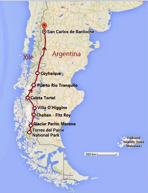
Some borders between Chile and Argentina are easy to cross by car or bus and others are more tricky! You can see a map of the route I followed here:

Patagonia Trip
From Torres del Paine to Chaltén
I left Torres del Paine and crossed to Calafate, in Argentina. There are many things to do there, of the most interesting to visit the Perito Moreno(a glacier that neither grows nor decreases and has a front face with landslides every few minutes, really spectacular) and two hours north of Calafate, visit the Parque Nacional Los Glaciares, in Chaltén.
In Chaltén I met with my friend Allison and her parents, and we explored the park: Laguna de los Tres, with views of Fitz Roy peak and Laguna Torre with Cerro Torre in the background. We even saw a Huemul, a deer from this area quite difficult to see!
This park is incredible, with many day hikes, campings and the town of El Chaltén has a very nice atmosphere, with climbers, modern places to eat, and good ice cream shops! There is a more demanding route, the Cerro Huemul Route, lasting two to four days, for those who want more intense experiences.
Here I also met Ale, a Chilean friend I met in Barcelona. With her, we made a fantastic trip from Chaltén to the North.
From Chaltén to Villa ‘O’ Higgins
We left Chaltén and crossed the Laguna del Desierto by boat, a lake that used to be Chilean and is now Argentine. On the other side is the most picturesque border crossing I have ever seen! The Argentine gendarmerie was on the shores of the lake, with a soccer field and lots of chickens roaming freely. Once they put the exit stamp on our passports, we were in no man’s land!

Laguna del Desierto crossing Map
We climbed about 5 kilometers through a quite rough terrain where people who rode bikes suffered a lot. We camped on the edge of the border with Chile, and the next day we went down to Candelario Mansilla where they put the stamp of entry to Chile and took a boat to Villa ‘O’ Higgins.
From Villa ‘O’ Higgins to Coyhaique
Villa ‘O’ Higgins is a very quiet town, with a hill called Cerro Bandera, where you can see the town from above, and we even saw some condors flying above us.
Then we went to Caleta Tortel, a very pretty town with wooden walkways between the houses and no cars. It is very nice to see how the water rises and falls depending on the tides.
We continue north to Puerto Tranquilo, where the “Capillas de Mármol” (Marble Chapels) are located, a spectacle of nature that is worth exploring by boat.
From Tapera to Bariloche
In Coyhaique we met with Roberto and his family and went to the river for a soak.
The next day we went to Tapera, a border site with Argentina, and we observed how Gauchos (Argentine cowboys) and Huasos (Chilean cowboys) shared culture and food in an atmosphere of brotherhood. They roasted a few lambs, and they drank all the wine in the region! The relationship between the inhabitants of both sides of the border reveals the artificial barriers that humans create with borders.
Ale took a plane to Santiago, Roberto returned to Coyahique, and I went to Bariloche, crossing again through Futaleufú and Esquel, to once again observe the incredible blue tones of Lake Nahuel Huapi at sunset.
Cheers!

Leave a Reply